
Recently, we wrote about St. Paul’s worst bike lanes, several of which are not for the faint of heart or skinny of tire. But some of those bikeways could be considered acceptable… if not for the city routes that make everything else look bad.
Minneapolis has been rightly praised for the Midtown Greenway, which spans its entire width. St. Paul lacks such a high profile route, but makes full use of its parkways, creeks, and river valleys, offering spectacular views and long recreational rides uninterrupted by car traffic. Regrettably, only two of these routes serve downtown—and none connect downtown with the western half of the city. In fact, almost all the best routes are on the east side or west side (which is, of course, in the southeast corner of town). Many are part of the Grand Round, which circles the city but offers little usefulness for most commuters.
St. Paul also has hills. Lots of them. And to fully enjoy cycling the capital city, one must learn to love the ascent as much as the descent. Or, invest in an eBike! Either way, embrace the hills—they’re good for you.
For visitors from the glacial flats of Minneapolis, we’ll give each route a hill index from 1 (not much worse than the Greenway) to 5 (OMG I thought they were bluffing about hills!).
A Magical Ride Through Swede Hollow on the Bruce Vento Trail
For over a century, Swede Hollow was a shantytown tightly bound by railroad tracks and ravines. Today, it offers a rich history, wildlife, and a feeling of being hidden from the world above. There are two trail options through the hollow: The eastern section runs closer to the daylighted sections of Lower Phalen Creek and features a short but steep climb up to Swedehenge. (Yes, Swedehenge.) The main, western option is more direct, wider, and less hilly.
The north end of the park skirts the crumbling ruins of the Hamm’s Brewery, which seems more derelict and mysterious down in the Hollow than the restored areas up above. But the true highlight is the amazing 7th Street Improvement Arches and their helicoidal spiral limestone construction. This architectural wonder catches you by surprise. From the outside it looks like any typical trail tunnel, But once under the arches, the effect is ethereal and hard to describe. If you haven’t biked or walked through Swede Hollow—go now.
The Bruce Vento Trail through Swede Hollow offers easy connections to Lake Phalen, the Gateway Trail, and Downtown St. Paul via Positively Fourth Street.
Hill index: 2/5.
Como Avenue and Wheelock Parkway
When the city completed this northern section of the Grand Round, it opened up more fun off-street bike routes than possibly any other trail. The eight miles of dedicated trails along Como Avenue and Wheelock Parkway are top quality, with mostly raised intersections that slows drivers and eliminate bumpy curb cuts for cyclists. Just watch out in the few busy sections—as usual, turning drivers are pretty oblivious of trail users.
What makes this bikeway special is the variety of destinations and connections it serves. Connect with the U of M Transitway and head to Minneapolis, tour the fairgrounds off-season to experience the mighty empty Midway, visit Como Zoo, connect to the Gateway State Trail, or explore the Saint Paul - Changsha China Friendship Garden. And you can travel from Saint Anthony Park to Lake Phalen completely car-free (or rather, you will soon be able to once the last segment from Edgerton to Arcade is finished).
Como Avenue is relatively flat, but If you ride eastward along Wheelock, a highlight is gliding down the curves of hill between Idaho and Marion, feeling like you’re literally flying. Of course, heading the other direction many cyclists dread the same uphill. There’s one more hilly stretch between Edgerton and the Gateway, but otherwise, the route is fairly flat.
Hill index: 3/5
Trout Brook: A Hidden Natural Gem in the Heart of the City
The two short sections of trail that follow the Trout Brook Creek watershed just west of 35E offer some of the most unique urban cycling experiences in the Twin Cities. In winter, you’ll often see bald eagles close by in low trees or hundreds of ducks concentrated in the open water by the St. Paul Water Plant.
The middle section along Jackson Street between Arlington and Maryland is currently a drag, but is hopefully scheduled to see off-street facilities added within the next few years—some interim pothole remediation would be very welcome in the meantime.
On the lower section, if you can tune out the roar of nearby 35E, you could easily imagine you’re out in the prairie, with wildflowers, pollinators, lots of bird species, and deer. The upper section is much more hemmed in, following a curving track back and forth over Trout Brook next to an active railroad corridor. If you hate hills, start at the top and it’s basically all downhill, since you’re following a creekbed.
Hill index: 3/5
Margaret Street Bicycle Boulevard
In the recent past, St. Paul briefly experimented with the concept of bicycle boulevards (with varying degrees of success). A bicycle boulevard converts a quiet residential street into a safe bikeway with traffic diverters and traffic circles to slow traffic and protect cyclists.
Margaret Street, which runs from Swede Hollow to St. Paul’s eastern border at McKnight, is by far the city’s best implementation of the bicycle boulevard concept, with five traffic circles, a traffic diverter at Johnson Parkway, multiple curb bump outs, and even a curbside button that cyclists can press to completely stop traffic on White Bear Avenue. (Try it—it’s hella fun! Press it repeatedly and you might just turn White Bear Avenue into something other than a deadly urban raceway!)
Biking the Margeway is peaceful and relaxing. There are some gnarly hills, but the overall vibe is excellent. Hopefully the city’s other bicycle boulevards like Charles and Jefferson Avenues will someday be improved to match Margaret Street.
Hill Index: 4/5
Lilydale: Ghosts of A Village Past
Winding through a low spit of land between 35E and Harriet Island on the west bank of the Mississippi, Lilydale Regional Park’s trails are a wonderful way to connect with nature in the heart of the city.
Once a complete neighborhood, Lilydale was wracked by repeated floods in the ’60s and ’70s, its buildings destroyed and foundations bulldozed into the river. Technically part of the village of Lilydale and Dakota County, the city of St. Paul owns and manages the parkland. It still floods every few years, and Water Street is often closed to car traffic in the spring due to high water levels.
Lilydale’s trails are an important link between Mendota and the Big Rivers Trail to the west and St. Paul’s new Robert Piram trail to the east. Points of interest include an elegant new picnic pavilion overlooking Pickerel Lake, the remains of an old brick factory, and close-up views of both the High Bridge and the Lilydale Swing Bridge. It’s a ride unlike anywhere else in the Twin Cities.
Hill Index: 1/5
Sam Morgan Through the Seasons
Sandwiched between the Mississippi and the terribly overbuilt and unnecessary Shepard Road, the Sam Morgan trail runs through downtown Saint Paul from Crosby Farm Regional Park’s network of trails to Mounds Parkway. Passing close to river tugs, busy freight rail lines, and grain elevators, Sam Morgan offers a view of the working river many locals never see. The changing seasons are also on full display, from springtime floods engulfing Raspberry Island to flocks of eagles fishing along open water near the High Bridge in the depths of winter.
In warm weather, the trail can be uncomfortably busy. And there are a few rough patches, especially under the Robert Street bridge. But Sam Morgan is overall a year round gem.
Hill Index: 1/5
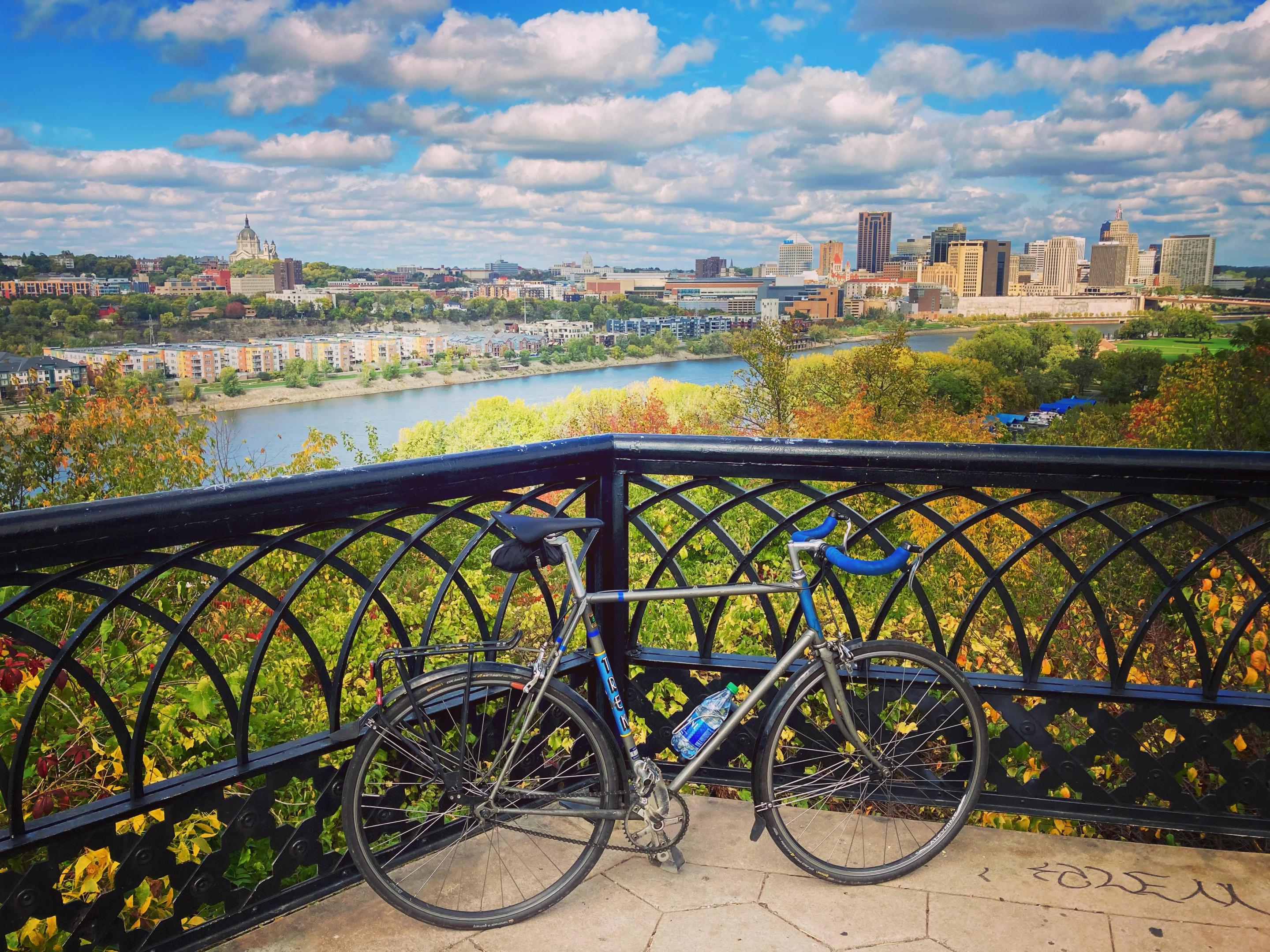
Up the Bluffs on Ohio Street & Cherokee Park
To truly love cycling in St. Paul, just take the advice of the great Eddy Merckx: Don’t buy upgrades, ride up grades! There’s no better place to start than Ohio Street on the Westside.
One of few switchback routes in the Twin Cities, Ohio Street winds steeply up the river bluff from Harriet Island. Drivers seem to crash their cars often on these tight turns, so Ohio’s fully protected bike lane allows both cyclists and pedestrians to focus on the climb without fear of death. Ohio is second only to Ramsey Street as the city’s steepest bike route, but we don’t speak of Ramsey Hill in polite company.
In 2019, Alix Magner cycled up Ohio Street 170 times over the course of 23 hours to equal the elevation of Mount Everest, a truly amazing accomplishment. Fortunately, you’ll only need to climb it once to enjoy the amazing views atop the bluff. In particular, be sure to visit the overlook near the top of the High Bridge for one of the best views in the entire state.
West of the High Bridge, the trail continues through Cherokee Park, which offers more beautiful vistas from atop the river bluffs.
Hill Index: 5/5
Robert Piram Trail’s Journey into Kaposia
The Robert Piram Trail through the Westside Flats is truly a remarkable success story, one in which the city recognized a critical gap in infrastructure and patiently acquired the right of way and funding to bridge the gap.
Piram connects Harriet Island with South St. Paul’s Kaposia Landing Park, winding past Highway 52, the St. Paul Airport, a host of dump sites, river barge terminals, the city’s impound lot, and a tangle of railroads. The abrupt and surreal shifts in scenery along the Piram trail are well worth the ride. And, it completes a missing link in an incredibly scenic bikeway which extends (almost) uninterrupted from Minneapolis all the way to Hastings.
If riding along the river isn’t hilly enough for you, cross the pedestrian bridge at Kaposia Landing and climb up Simon’s Ravine into the highlands of West St. Paul. You’ll have tree trunk legs in no time!
Hill Index: 2/5
Mounds Parkway & Upper Afton Road
Climbing steeply up Dayton’s Bluff east of downtown St. Paul, Mounds Boulevard rewards the effort with more spectacular views. The city recently rebuilt the trail along Mounds Boulevard and reconfigured walking trails to prevent erosion and respect the remaining burial mounds atop the city’s famous white sandstone cliffs. Signs and monuments remind visitors that the park is a sacred burial site.
The view from atop the bluff is truly breathtaking, as it must have been when indigenous people built the mounds over a thousand years ago. The trail offers multiple vantage points of downtown and the industrial expanse around Pigs Eye Lake.
The Mounds Boulevard Trail connects northward to the new Johnson Parkway trail, which leads to Lake Phalen. Or, follow the trail down Burns Avenue across Highway 61. The highway crossing is terrible and requires extreme caution, but just on the other side rises Upper Afton Road, a very hilly but relatively quiet residential street with good pavement and a fine painted bike lane. Upper Afton is a rare example of a painted lane in St. Paul that feels wholly sufficient.
Hill Index: 5/5
Battle Creek Park & Fish Hatchery Trail
The best reason to suffer Upper Afton Road’s hills is the opportunity to ride down through Battle Creek Park. Bombing down the paved trail is intense, with tight turns, repeated crossings of Battle Creek, and several caves to explore along the way. An extensive network of steep mountain bike trails also weave throughout the park.
At the bottom, the trail boops through a tunnel under Highway 61 and becomes the Fish Hatchery Trail. …Yes, we previously ranked the Fish Hatchery Trail as one of the worst bike routes in the city, but it’s also one of the best. Somewhere here is the duality of biking in St. Paul; taking the good with the bad, the ascents with the descents, the natural beauty with rust belt ruins.
Hill Index: 5/5
Ye Olde Ayd Mill Road Trail
Ayd Mill Trail is best viewed as a downpayment on what could one day be the single best, continuous urban bike route in the United States. If the various agencies responsible can ever manage to assemble the needed pieces to continue the Midtown Greenway across the Mississippi and extend it to downtown St. Paul, the impact would be incredible.
Ayd Mill is the first St. Paul section of the route that will hopefully one day exist. For now, it’s a comfortable, fast route to travel through a part of the city with few direct options (largely thanks to Ayd Mill Road itself, ironically). The trail is loud due to excessive cut-through traffic between 35E and I94, and could stand to have better starts and ends (especially at Selby). In fact, under the Selby bridge is the Ayd Mill Ice Floe, a thick layer of frozen meltwater that covers the trail every year in March. Watch out for that!
Related: You don’t need a bike to enjoy Ayd Mill Road! There’s no driving pleasure in St. Paul greater than going the 35mph speed limit in the single northbound lane, herding a lengthy chain of impatient tailgaters behind you like a good ol’ fashioned urban cowboy.
Hill index: 1/5, except for the off-ramp to Grand Avenue, which is steep!
Honorable Mention: the Capital City Bikeway
The Capital City Bikeway (CCB) is a work in progress in downtown St. Paul. With the stated goal of “[p]lacing a majority of downtown within a few blocks of a bike and pedestrian trail,” the bikeway has grown steadily since the first protected bikeway was installed along Jackson Street in 2017. The next leg of the network will be along Wabasha, which is currently under construction, followed by Kellogg Boulevard in 2023.
The CCB is upgrading St. Paul to something closer to the standards of downtown Minneapolis with a network of connected trails. Unfortunately, the culture of downtown St. Paul has some catching up to do. Property owners routinely plow snow into the bikeway, cars exit parking ramps without checking the trail for cyclists, and the lanes are often blocked by delivery trucks. But these kinds of things are true in every city in America, where cars dominate every aspect of life.
But, no matter how much we prioritize cars, drivers will never see Swede Hollow or Trout Brook. Never view the city from up on the High Bridge Overlook or Indian Mounds Park. To experience the best that St. Paul has to offer, you’re just gonna have to get out of your car.
Hill index: 2/5.