


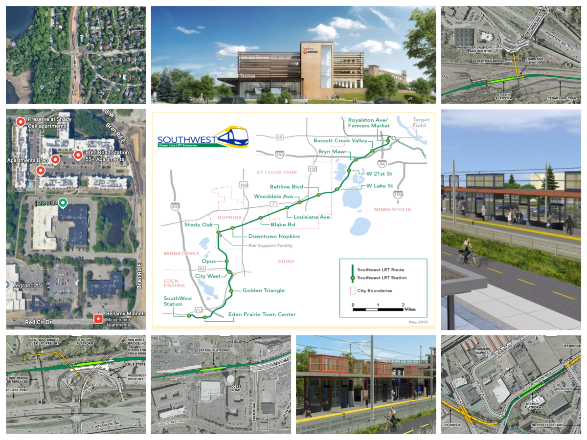
The Green Line Extension, the most expensive public works project in Minnesota history at $3.58 billion, kicked off in 2009 with an estimated completion date of 2015 and an expected cost of $1 billion. Last month, the Met Council finally announced an opening date of... June 12, 2027, a full 12 years later.
By the time the expansion is done it will be old enough to vote for itself. But in the southwest suburbs, the new stations have been finished for years while we’ve waited for Minneapolitans to get their portion done.
Why the delay? Planners originally had projections that going through Uptown (likely from the Midtown Greenway to Nicollet Avenue) would have been more difficult, so they looked to go around it, picking the existing rail corridor between Cedar Lake and Lake of the Isles. Sounds great, right? Commercial rail is already there, and you don’t have to tear up a street and listen to endless community bickering about road design. (Lyndale and Bryant avenue redesigns, I’m looking at YOU.)
Two big problems derailed the Met Council’s plan. The first is that railroad property is not subject to eminent domain, meaning that when a government wants to use railroad property, it has no legal way to force the railroad to do anything. Nada. Zip. Zilch. The BNSF Railway’s reply to Met Council negotiations more or less boiled down to: "My offer to you is this: nothing."
What had seemed like a cheaper route than going through Uptown instead required a quagmire of concessions to BNSF. Rail line spacing was debated, crash walls were added, and, eventually, an LRT tunnel had to be dug to preserve rail safety in the corridor. Safety is good, but the corridor then faced its second problem: The tunnel went through pudding. Lake of the Isles is a reclaimed swamp, and working underground nearby proved to be nightmare. It was, indeed, daft to build on a swamp.
But now we’re in the home stretch. Even with all the delays, the completed stations still show the potential of this new light-rail line. The adjacent bike trail is one of the most delightful parts of living in Eden Prairie. For years riding along that trail I watched platforms being built and tracks getting laid. Now landscaping is planted and sculptures are getting installed. The line is still being tested, but soon the public will get to see these new stations in action. Here’s what you can expect when the Met Council finally finishes… workin’ on the railroad.
The Good
Light rail is meant to connect people to jobs and get cars off the road. It’s got wider station spacing than a street car but is closer than commuter rail, and federal dollar-matching rules often encourage the routes to go from the suburbs to a downtown area. Along the way, ideally, it connects as many people as possible to the route. Researchers have found a half mile is about the furthest most people are willing to walk to an LRT stop. The best stations on the route serve the non-driving population or at least minimize car trips.
SouthWest Station
The biggest—and certainly the shiniest—is SouthWest Station. The first station on the line expanded a large, pre-existing park-and-ride ramp to create a true multimodal transit hub right in the heart of Eden Prairie. About 950 parking spaces are available above the new LRT tracks, which lie conveniently parallel to the bus stops. There’s also a full waiting area with vending machines, restrooms, and actual humans selling tickets.
Not only does SouthWest Station provide easy options to get to and from downtown with an expected travel time of 30–35 minutes, it’s bracketed by large condo/apartment buildings on both sides. Both Southwest Transit and Metro Transit are realigning buses to the new LRT stations, and the terminus will no doubt draw additional riders from the several large apartment complexes surrounding Purgatory Park.
And while this station isn’t close to the big mall, it does have its own strip mall with restaurants, shops, a dentist, and other businesses. The only other thing I wish it had is a sign with the click-clack tumbling letters like the train stations in Europe.
Opus Station
Another example of the right station in the right place is the Opus Station. This stop isn’t glitzy, but it’s in exactly the right spot: the middle of Minnetonka’s bizarrely named, retro-futuristic, mixed-use development Opus 2. (There was no Opus 1 and there won’t be an Opus 3.) It’s lucky the train will let people walk around here now because the looping one-way roads in this planned area were so confusing drivers famously could not navigate the layout.
Minnetonka is rebuilding much of the surrounding area to integrate the new station. The plan drew hundreds of new housing units nearby and, if you look at the map above, I’ve highlighted just a few of about a dozen apartment buildings within an easy walk. According to the Met Council, there are more than 12,000 jobs within the Opus 2 *snicker* business park.
Golden Triangle Station
A good station doesn’t have to have everything to stand out. For example, the Golden Triangle Station is a job hub. For the uninitiated, Eden Prairie’s Golden Triangle is the space between highways 212, 494, and 169. In SimCity-speak, it’s where city planners put all the pale yellow Light Industrial Zoning blocks. The Green Line was purposefully routed through this region to get folks from both directions to work.
Shady Oak Station
Also on the edge of Hopkins and Minnetonka is the Shady Oak Station, a large park-and-ride just off Excelsior Boulevard. This is where the route joins the Minnesota River Bluffs’ LRT bike trail, which goes all the way from Chaska to Minneapolis. I expect a decent number of people will actually bike commute from this station, as it’s in the heart of another industrial jobs zone to the south.
West Lake Street Station
Another winner is the West Lake Street Station next to Bde Maka Ska. It’s right in the middle of a pre-existing dense collection of housing, shops, grocery stores, and health clinics. The station itself is massive and boasts an elegant, modern elevator structure connecting to the Lake Street flyover bridge. I bet it’ll draw even more people to the area.
Downtown Hopkins Station
While all of those locations are great, my absolute favorite is the Downtown Hopkins Station. Hopkins has a rich railroad history. In the 1800s, three major railroads cut through the area. By 1901, the 'burb had become the largest railroad hub west of Chicago—you could literally take a “Midnight Train to Georgia.” Street cars were strung out to the growing city in the early 1900s, but the tracks were ripped up in 1951.
Seventy-six years later passenger rail is being restored. The original depot, now a coffee shop, is marooned from downtown by the massive overpass of Highway 169. However, the new stop is right next to downtown Hopkins on Eighth Avenue, which has already been reconfigured to be pedestrian- and bike-friendly.
The station also features a public plaza with large sculptures sponsored by the Hopkins Center for the Arts and a drop-off area on busy Excelsior Boulevard. And take a close look at that rendering above: That is covered bike parking!! Like the SouthWest Station, this is going to be a legitimate destination by itself. But, because god has a sense of irony, it’s also right outside of a Honda dealership.
The Bad
Any big project like this will have hits and misses, and some of the stations are legit head scratchers.
Eden Prairie Town Center Station
Based on that name, you might think the second station on the line is near the thing the entire city was planned around: the mall. However, due again to right-of-way expenses and the risk that cars would be inconvenienced, the station is more than a half-mile away from Eden Prairie Center. While nearby roads do have sidewalks, pedestrians are clearly secondary.
And it gets weirder: The station is tucked behind a bowling alley on a cul-de-sac. There are a couple of apartment buildings next door at least, but the large parking lot to the north, which belongs to the industrial instrumentation company Emerson, is completely fenced off from the station—you literally cannot get to anything on the north side of the tracks besides a steakhouse.
The Eden Prairie Costco and Asia Mall are also just to the northwest, and getting there requires trekking around Lake Idlewild. The saddest part is that the city has been discussing light rail with Hennepin County since the ’80s and still couldn’t do any better. The one ray of hope? Most of the stations have been attracting development, so hopefully this one will make more sense in the future.
The Royalston Avenue/Farmers Market Station
Another clunker is the Royalston Avenue/Farmers Market Station. With the exception of the West Lake Street Station, Minneapolis really got the shaft with this entire line. This stop apparently needed to exist because “the surrounding area is a prime location for residential and commercial development with an industrial backdrop,” despite being a 30-second train ride from Target Field Station, and is supposedly “within walking distance of the Minneapolis Farmers Market, Target Field, and the Hennepin Theater District.” Well, one of those things is true.
Do you know what is within walking distance of Target Field and the Hennepin Theater District? THE EXISTING STATIONS RIGHT NEXT TO THOSE THINGS. Yes, this area will probably change and maybe useful stuff will crop up nearby, but it sure ain’t there now. And as a final fun note: This station itself is within a half mile of the Target Field station, so everything it supposedly enables access to already had it.
The Basset Creek Valley Station
Things go from bad to worse just to the west. The Basset Creek Valley Station does provide easy access to the Minneapolis Impound Lot to the north and the Dunwoody campus to the south, but that's the end of the good news. I’ve biked through here several times and, folks, that underpass below I-394 is scary even in the daylight.
The station is somewhat close to Near North, though hopefully a Blue Line extension will serve that area better. (Don’t worry, Minneapolis has a great history of doing the right thing for the folks in Near North.) So what is there? The city of Minneapolis’s precious gravel storage. They didn’t even have the shame to crop it out in the photo above!
This station is expected to have the lowest ridership in the entire line, though that’s not accounting for the supposed development plans that the city has in mind for this area. Officials have been planning to do something with this plot for 20 years, I’m sure they’ll get started any day now. In the meantime, c’mon kids, let’s all go to the spooky underpass and look at the gravel piles!
The Ugly
After the standoff between BNSF and Minneapolis, at least the stops by the bog tunnel are good, right? (Padme meme *INTENSIFIES*) Right???
West 21st Street Station
Sandwiched between the former nude/stoner beach on Cedar Lake (aka Hidden Beach) and the Pohlad zone west of Lake of the Isles, the first station after the train emerges no doubt cost a fistful of dollars, but at least it’s in a highly-populated area. *Touches hand to earpiece*... I’m sorry I’m getting an update… my editor says to lay off the sarcasm and spaghetti western references.
Anyway, I’m all for public use of Cedar Lake but seriously, go look at the houses nearby and guess how many of the homeowners will walk to a train station. I’m sure it will serve dozens of people. It is next to the Cedar Lake Mudpit, so it has that going for it, which is nice.
Bryn Mawr Station
I’ve saved the worst for last: The Bryn Mawr station is in a meadow. A meadow. It lies in the Death Star trash compactor between the cliffs of the Kenwood neighborhood to the south and existing commercial rail to the north.
This is where the BNSF crash wall begins, which you’ll remember only cost a few dollars more (sorry). There’s nothing here! It requires a giant pedestrian bridge of ironworks just to connect to anything useful, and naturally there’s no plan to include bus service across I-394. The Bryn Mawr neighborhood is within a half mile, but you know what would be even better? A station next to that neighborhood! We can’t afford that, so we have to fund another seven years of construction on I-494.
To atone, Met Council offered a half-hearted olive branch, setting the stop right where the Cedar Lake Bike Trail connects. I guess if you’ve already ridden 80% of the way from St. Louis Park to Minneapolis and you forgot to bring an energy bar you can hop a train the rest of the way there. There is no way to ever develop this location and it’s not near anything. I award this station no points, and may god have mercy on its soul.
It’s Time to Get This Long Train Runnin’
It’s easy to Monday morning quarterback the extension’s failures, so let’s. The route choice was a foreseeable fumble, trying to stiff arm commercial rail led to a three-year penalty, and the Minnesota Legislature’s audit made the Met Council look worse than this year’s San Diego Chargers. This project has had a lot of problems, and we as citizens should demand better.
The good news is the Blue Line Extension has learned some lessons: The original route would have run next to BNSF railroad tracks, completely skipping around north Minneapolis, and now is going to run down the old trolley line on Broadway Avenue. That of course raises the initial price tag, but hopefully avoids ludicrous delays and cost overruns from poor planning.
An ideal light-rail line connects the dots between places people really want to go. The Green Line Extension was plagued with problems, but the good parts are already visible. The route hits some great density of jobs and housing, and it should get cars off the road. And hopefully, given enough time, development will adapt to the line and integrate the worst parts.
Get ready, the train starts rolling on June 12, 2027. C’mon and ride it.