
This story originally appeared on The Minnesota Historian, the local history website run by Josh Biber.
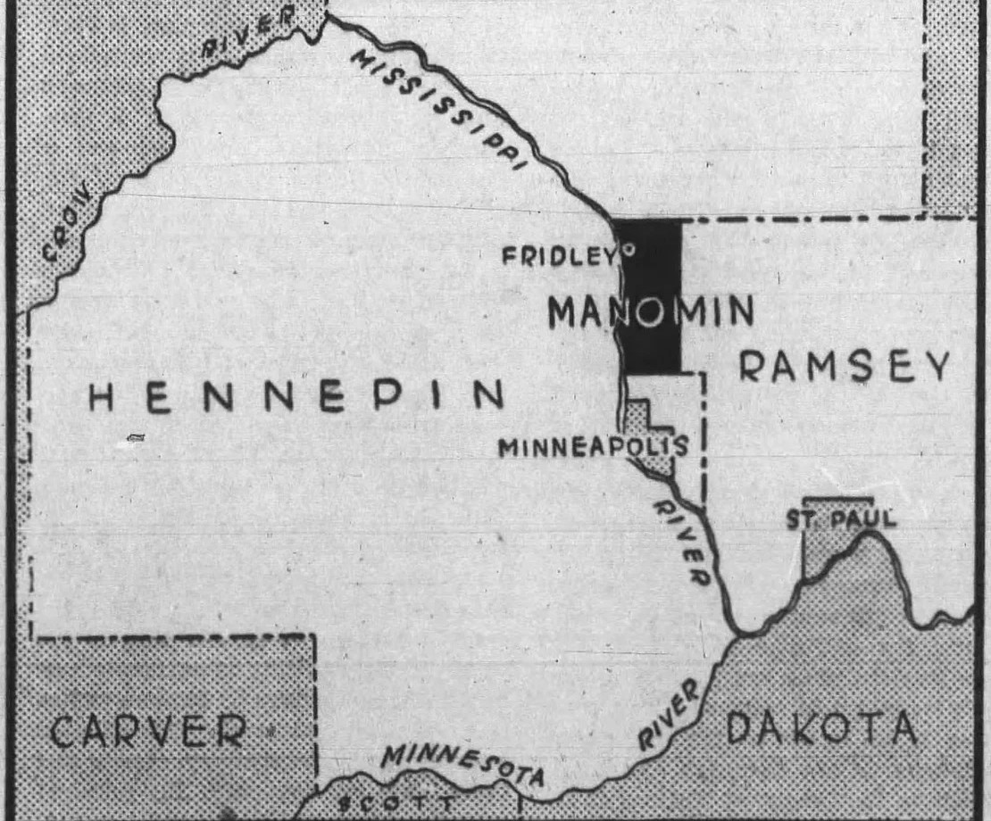
Manomin County—an anglicized spelling variant for the Ojibwe word for wild rice, Manoomin—encompassed the present-day cities of Fridley, Spring Lake Park, Columbia Heights, and Hilltop. Although the county only existed for a short period of time, there was no shortage of stories and drama that kept the boisterous little community in the newspapers; the citizens of Manomin saw the territory of Minnesota become the 32nd state, lived through the Civil War and the U.S.-Dakota War of 1862, and even had a little spat of their own with the rest of the state.
The Establishment of a Village
A few years before the creation of Manomin County, John Banfill arrived. Banfill, the first Euro-American settler in the area, was looking for a strategic place to build a tavern and start a new pioneer town. In 1847, he selected what he believed to be the perfect plot of land near the confluence of Rice Creek and the Mississippi River. This slice of the Minnesota Territory was a prime place for a village. Nestled between the Mississippi and a carriageway known as the Red River Ox Cart Trail, there was an abundance of rich soil for cultivation and easily accessible fresh water. The Red River Ox Cart Trail (now East River Road) ran along the eastern bank of the Mississippi River and served as a busy fur-trading route between Minneapolis to the south and the Red River Valley to the north.
During Banfill’s first year there, he built the still-standing Greek Revival-stylized house known as the Banfill Tavern. This building served as Banfill’s home, the community tavern, a post office, an inn, a general store, and a dairy farm. Banfill experienced prosperity as workers from nearby lumber operations patronized the tavern. Situated roughly a day’s trip from Minneapolis and St. Paul by carriage, the inn was also a hit, as was Banfill's Mississippi River ferry service.
Banfill platted the village of Manomin in 1851 as more pioneers began to move into the area and build homesteads and farms. Manomin quickly eclipsed 100 citizens, blossoming into a little village with a strategic location. Farming was the main commercial activity, though other businesses soon sprouted up alongside Rice Creek, including a second general store, sawmill, flour mill, and a cooperage.
Rice Creek was named after Henry Mower Rice. Originally from Vermont, Rice settled in Manomin after previous tenures as a surveyor in Michigan at Sault Ste. Marie and as a sutler at Fort Atkinson in Iowa. Rice purchased hundreds of acres of land to farm in Manomin in 1849. By 1850, his large estate was completed on his considerable riverside acreage. Built with bricks shipped up the Mississippi from St. Louis, the Rice estate was a stark contrast to the log cabins and small one-bedroom homes of other settlers in Manomin. He'd only live there for a few months. After Rice married, he and his wife sold their property to a man named Abram Fridley. Rice and his wife moved to Mendota where he took up a position with the American Fur Company.
Abram Fridley’s Influence
As the small village of Manomin was taking shape, Fridley quickly rose to prominence in the burgeoning community. Fridley already had a lengthy resume as a former Native American agent in Long Prairie, Minnesota Territorial House legislator, and former sheriff for Ramsey County.
After these ventures ended, Fridley purchased the former Rice Estate in Manomin and several other swaths of property. Fridley’s first order of business was to incorporate a new county. During a special territorial legislature session in 1857, he used his influence to constitute and organize Manomin into the new County of Manomin. This new county was given the same rights and privileges as other organized counties in what was then the Minnesota Territory. Fridley adorned himself as “Chairman of County Commissioners for Manomin County," and drew the county's modest borders. Thus, Minnesota’s smallest county was born.
Fridley essentially acted as the king of Manomin County during his reign, establishing tremendous power and influence over its the citizens. Thomas Coleman, a Manominite at the time, reminisced:
“I went to Major Fridley’s one day when I was about 20 and was told I was to be Sheriff of Manomin County. I said that was all right with me. The major gave me some papers to sign as sheriff and I did it. Then the Major gave me two dollars and told me I wasn’t sheriff any more. Major Fridley was always doing things like that.”
The 1860s saw ups and downs for Manomin County. A new form of transportation—the steam-powered locomotive—was introduced in the early 1860s. Fridley helped persuade the St. Paul & Pacific Railroad to extend a new line of track from St. Paul and Minneapolis to Anoka, reaching Manomin in 1863. Trains greatly reduced the 15-mile journey to St. Paul from a day’s travel on the Red River Ox Cart Trail to only an hour by passenger rail. Around that time, the Red River Ox Cart Trail became an upgraded new military road connecting Fort Ripley in the north to Fort Snelling to the south. Paired with increased ferry travel on the adjacent Mississippi River, Manomin County was expected to become a boom town with these new logistical improvements.
The Decline of Manomin
However, further progress in Manomin stagnated as the population reached its peak of 136 citizens. Due, in part, to Fridley’s political divisiveness, Manomin County began to be viewed as an outsider by the rest of Minnesota. Fridley was a dichotomous political figure. On one hand, he was on the forefront of introducing a bill supporting the women's suffrage movement in Minnesota. On the other, he was an outspoken supporter of the Southern Democrats—the party that led the charge to secede from the U.S. to form the Confederacy. Fridley’s staunch Dixiecratic views seeped throughout Manomin County, while Abraham Lincoln’s abolition-focused Republican Party resonated more with the rest of Minnesota. In the 1860 presidential election, not a single vote was cast for Lincoln in Manomin County, but the state’s electorate voted for Lincoln and the abolition of slavery.
As a result, a slurry of controversial and fictitious attack stories by anti-slavery news publications in Minnesota dramatized Manomin County’s political views. The political attack ads fictitiously accusing a mob of Manominites of hanging slavery abolitionists, barricading roads leading into Manomin, and seceding from Minnesota to form the independent Union of Manomin. One such ad read:
“We received by the Pony Express, intelligence of the most startling character, from Manomin. Secession sentiments are spreading into the North. Manomin county has already determined to secede before the first of January... Preparations are now making to take Fort Snelling, as soon as the new government is formed. Republicans have been all ordered to leave the county forthwith. Governor Fridley has ordered the army to be increased to one hundred thousand able bodied men, in case of war… Extensive preparations are making for the first of January when a new Constitution will be adopted, and the new flag of Manomin thrown to the breeze.”
Shortly after this fabricated assault on Manomin’s loyalty to Minnesota, hostilities between the north and south erupted and the Civil War began. The Manomin vs. Minnesota bickering was cast aside as both Fridley and the citizens of Manomin aligned their support with the rest of Minnesota and the Union during the war.
The Dissolution of Manomin County
When the Civil War ended, sentiments in Manomin shifted. The stark reality of the war had paid a heavy toll on the country, and residents of Manomin County began rejecting most of Fridley's contrarian posturing. Besides, Minnesota was approaching its first decade of statehood. The state government had grown increasingly influential, and leaders felt that Manomin County was too small to remain as an independent county. By 1870, the citizens of Manomin County successfully petitioned the state legislature to have their county absorbed by Anoka County.
Fridley's Last Act
On his way out as Chairman of County Commissioners for Manomin County, Abram Fridley made one last motion to the state legislature to change the name of the newly reorganized township in Anoka. Fridley’s motion was approved in 1879, and the township of Manomin was retired for the name we know today: Fridley.
Sources:
- “About Fridley” City of Fridley. https://springbrooknaturecenter.org/341/About-Fridley#:~:text=1879%3A%20The%20area's%20name%20changed,a%20Home%20Rule%20Charter%20City.
- “The Minnesota Story: Unknown County” The Winona Daily News, September 30, 1958. P. 6.
- “Lost - Two Whole Counties in Minnesota” The Minneapolis Journal, July 27, 1901. P. 11.
- “History, Current Demographics, and Projections” City of Fridley. https://fridleymn.gov/DocumentCenter/View/659/Chapter-2-History-Current-Demographics-and-Projections
- Potter, Merle. “Major Fridley’s Kingdom of Manomin” The Journal Magazine, September 4, 1932. P. 2.
- “Rice Creek Camp is Named Manomin” The Minneapolis Tribune, September 28, 1930. P. 12.
- “Railroad Pioneering” St. Cloud Times, June 2, 1932. P. 12.
- “Startling News by Pony Express” Falls Evening News, December 22, 1860. P. 2.
- Bennett, L.G.. "Map of Ramsey and Manomin Counties and Hennepin East, Minnesota. 1867." Hennepin County Library, James K. Hosmer Special Collections Library, collection.mndigital.org/catalog/mpls:318
- Hill, Kelley & Company "John Banfill of Manomin, member of the First State Legislature" Minnesota Historical Society, 1858. https://collections.mnhs.org/cms/largerimage?irn=10323306&catirn=10761961&return=
- Healy, G. P. A. (George Peter Alexander) "Henry M. Rice" Minnesota Historical Society, 1857. http://collections.mnhs.org/cms/largerimage?irn=10413478&catirn=10186485&return=count%3D25%26q%3Dhenry%2520mower%2520rice%26startindex%3D26%26tab%3Dresearch_items
- By Unknown author - Visual Resources Database, Minnesota Historical Society; Location no. por 20399 p1; Negative no. 91252, Public Domain, https://commons.wikimedia.org/w/index.php?curid=12229295
- Map of Anoka County, Minn. (Published by A.T. Andreas, Lakeside Building, Chicago, 1874. Chas. Shober & Co. Proprietors of Chicago Lith. Co.)